
|
|
|
|
Главная --> Промиздат --> Map principle 3.2.2 Universal Transverse Mercator In this section we want to define a LOCATION with the UTM coordinate system, again for the Spearfish region, but now with NAD83 datum and the related GRS80 ellipsoid. To create the new LOCATION, we first start GRASS: grass53 GRASS starts with the TclTk interface that allows you to select your LOCATION and MAPSET. Because we want to define a new project we select Create new which brings us to the classic, non-graphical startup screen (compare Figure 3.5, dialog shortened here): 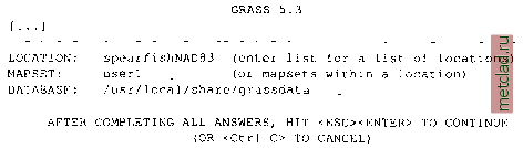 For LOCATION enter the name for your new project (in our case spearfishNAD83), for MAPSET you can enter your name and for DATABASE you should have /usr/local/share/grassdata. Once you have entered the new LOCATION, MAPSET and DATABASE, you can continue with <ESC><ENTER>. Because this LOCATION does not exist yet, the following menu appears: 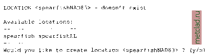 Type y and you will get the following message (here slightly modified): 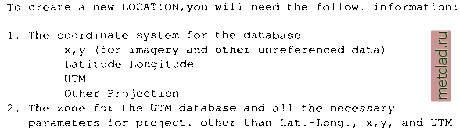 3. The coordinates of the area to become the default region and the grid resolution of this region 4. A short, one-line description or title for the location Do you have all information for location <spearfishNAD83>? у You can again type y and you will be asked to specify the new coordinate system: A X, у В Latitude-Longitude С UTM D Other Projection Type the appropriate letter, in our example it will be C for UTM. Note that the following sequence of questions will vary for different coordinate systems that require different parameters, as we will show in some additional examples: Please enter a one line descript. for location <spearfishNAD83> > Spearfish UTM/NAD83 ok? (y/n) [y] Do you wish to specify a geodetic datum for this location? у Please specify datum name Enter list for the list of available datums or custom if you wish to enter custom parameters Hit RETURN to cancel request >list Short Name Long Name / Description agd66 Australian Geodetic Datum 19 66 (australian ellipsoid) [. . .] Hit RETURN to cancel request >nad83 Now select Datum Transformation Parameters Enter list to see the list of available Parameter sets Enter the corresponding number, or <RETURN> to cancel request >list Number Details . . .] Used in Florida (PR0J.4 Params nadgrids=FL) Transforms Old NAD83 to HPGN NAD83 Used in Default nad83 region (PR0J.4 Params towgs84=0.ООО,0.ООО,0.000) Default 3-Parameter Transformation Now select Datum Transformation Parameters Enter list to see the list of available Parameter sets Enter the corresponding number, or <RETURN> to cancel request >6 Enter Zone: 13 Is this South Hemisphere (y/n) [n] n These are all the parameters needed for UTM (the system knows the other parameters like the valid ellipsoid GRS80). Next, you will be prompted to define your default region by defining the boundary coordinates of the project area and the default raster resolution: 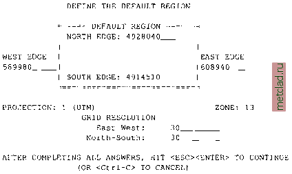 The default raster resolution (GRID RESOLUTION) is arbitrary, because you can change it later based on the needs of your application. However, it is useful to choose a meaningful number, for example, based on the resolution of data that you want to import or the resolution that you plan to use in your work. In our example, we have chosen 30 meters. This resolution does not affect the vector and site data, which are stored with precise coordinates. Also, every raster map may have its own resolution (see more about raster data resolution in Chapter 5). You can leave this screen with <ESC><ENTER> and then check the list of parameters that appears: 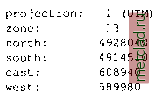
|