
|
|
|
|
Главная --> Промиздат --> Map principle 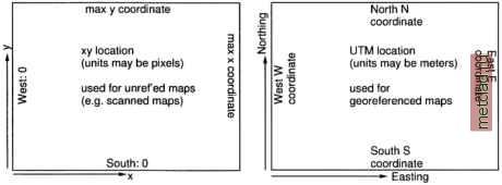 Figure 3.6. Definition of a xy LOCATION and of a projected LOCATION  From the previous sections, you should understand what latitude-longitude or UTM means and you should know, based on the data that you want to work with (or from your supervisor, customer or instructor), what coordinate system you are going to use (see Figure 3.6 for a general idea). You can type again y and you will be asked to specify the new coordinate system: 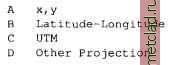 Type the appropriate letter, in our example it will be в for Latitude-Longitude. We accept and continue with: Please enter a one line description for location <spearfishLL> > Spearfish Latitude-Longitude WGSS? ok? (y/n) [y] у Do you wish to specify a geodetic datum for this location? у Please specify datum name Enter list for the list of available datums or custom if you wish to enter custom parameters Hit RETURN to cancel request >list Short Name Long Name / Description agd66 Australian Geodetic Datum 1966 (australian ellipsoid) wgs84 World Geodetic System 1984 (wgs84 ellipsoid) Please specify datum name Enter list for the list of available datums or custom if you wish to enter custom parameters Hit RETURN to cancel request >wgs84 Now select Datum Transformation Parameters Enter list to see the list of available Parameter sets Enter the corresponding number, or <RETURN> to cancel request Mist Number Details 1 Used in Default wgs83 region (PR0J.4 Params towgs84 = 0.ООО,0.ООО,0 . ООО) Default 3-Parameter Transformation Now select Datum Transformation Parameters Enter list to see the list of available Parameter sets Enter the corresponding number, or <RETURN> to cancel request >1 These are all required parameters for Latitude-Longitude. Next you will be prompted to define your default region by defining the boundary coordinates of the project area and the default raster resolution (here we use sexagesimal degree notation): 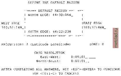 The default raster resolution (GRID RESOLUTION) is arbitrary, because you can change it later based on the needs of your application. For Latitude-Longitude LOCATIONs, you have to define the resolution in degree/minutes/seconds as well. You can leave this screen with <ESC><ENTER> and then check the list of parameters that appears: 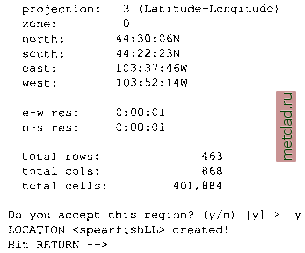 If everything is correct, type y and RETURN and you will get back to the startup screen. Type <ESC><ENTER> again and you will get the message that your MAPSET does not exist yet (note that the MAPSET PERMANENT was created automatically): 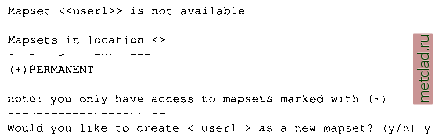 Type y and your new LOCATION with your MAPSET are created and GRASS prompt appears. You are now working in GRASS. You can check the definition of your LOCATION by running:  The last command prints the geodesic resolution of the region in meters. Now the LOCATION is ready, and you can start importing data.
|