
|
|
|
|
Главная --> Промиздат --> Map principle 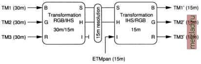 Figure 9.14. Geometric resolution improvement of LANDSAT-TM7 data (IHS image fusion method). After conversion from RGB to IHS color model, the resolution is changed from 30 m to 15 m. The high resolution panchromatic channel replaces the original intensity channel before converting back to RGB color model As an example, we enhance the geometrical resolution of geocoded LANDSAT-TM7 color channels (each at 30 m resolution) with the panchromatic ETMPAN channel (at 15 m resolution) of the same satellite acquired at the same time. Note that you can also use the SPOT-1 HRV/PAN images we used earlier in this chapter. Before starting the procedure as outlined in Figure 9.14, the input channels should be contrast enhanced with r.colors. The input channels are then converted to the IHS color model with i.rgb.his at 30 m resolution. Now the resolution is set to the higher resolution with g.region as defined by the panchromatic channel. In case of LANDS AT-TM7, it is changed from 30 m to 15 m; for SPOT data, from 20 m to 10 m. To improve the geometric resolution, the original intensity image which resulted from the RGB to IHS transformation is replaced by the panchromatic channel for back-transformation to the RGB color model. Finally, three new RGB channels at 15 m resolution containing the multispectral information from the input channels are generated. The GRASS procedure is as follows: #if not done yet, apply a contrast stretch (histogram equalized) g.region res=30 r.colors tm.l color=grey.eq r.colors tm.2 color=grey.eq r.colors tm.3 color=grey.eq #RGB view of RGB channels: d.rgb r=tm.3 g=tm.2 b=tm.l #RGB/IHS conversion: g.region res=15 i.rgb.his red input=tm.3 green input=tm.2 blue input=tm.1\ hue output=hue intensity output=int saturation output=sat #IHS/RGB back conversion with ETMPAN replacing #the old intensity image: 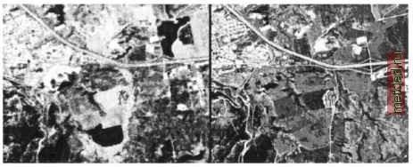 Figure 9.15. Left: Standard RGB composite of SPOT-1 HRV channels (20 m resolution); right: Image fusion of SPOT-1 HRV channels (20 m) with SPOT-1 PAN (10m) with Brovey transformation leading to resolution enhanced image (grey scale reproduction of color original) i.his.rgb hue input=hue intensity input=etmpan\ saturation input=sat red output=tm.3 15\ green output=tm.2 15 blue output=tm.1 15 #eventually new contrast enhancement: r.colors tm.l 15 color=grey.eq r.colors tm.2 15 color=grey.eq r.colors tm.3 15 color=grey.eq fresult is are the three color channels with improved ♦geometrical resolution: d.rgb r=tm.3 15 g=tm.2 15 b=tm.l 15 More complex merging procedures can also be performed. For geological applications, the use of ratio calculations (generated from r.mapcalc) is recommended, as they can be input into the fusion replacing the common multispectral input channels. 9.7.4 Image fusion with Brovey transformation An alternate method for image fusion is the Brovey transformation (described e.g. in Pohl and van Genderen, 1998, and among other methods in Zhou et al., 1998). The Brovey transformation method can be easily implemented in GRASS. The formula was originally developed for LANDSAT-TM5 and SPOT, but it also works well with LANDSAT-TM7. You need the panchromatic channel to be spatially co-registered to the multispectral channels. Image fusion based on Brovey transformation for LANDSAT-TM7 data merges the channels 2, 4, and 5 (all at 30 m resolution) with the panchromatic ETMPAN channel (at 15 m resolution): g.region res=15 r.mapcalc brov.red=l. * r.mapcalc brov.green=l. r.mapcalc brov.blue = l. tm.5 / (tm.2 + tm.4 + tm.5) * etmpan tm,4 /(tm.2 + tm.4 + tm.5) * etmpan tm.2 / (tm.2 + tm.4 + tm.5) * etmpan r.colors brov.red col=grey r.colors brov.green col=grey r.colors brov.blue col=grey d.rgb r=brov.red g=brov.green b=brov.blue Besides the improved resolution, the result provides a near-natural color table. You may consider modifying the color tables of the resulting channels to optimize the color quality to achieve a near-natural color image. For SPOT-1 data, the approach described above is slightly modified: g.region res=10 r.mapcalc brov.red= 1. r.mapcalc brov.green=l. r.mapcalc brov.blue= 1. spot.ms.3 / (spot.ms.1 + spot.ms.2\ + spot.ms.3) * spot.p * spot.ms.2 / (spot.ms.1 + spot.ms.2\ + spot.ms.3) * spot.p spot.ms.1 / (spot.ms.1 + spot.ms.3) spot.ms.2\ spot.p r.colors brov.red col=grey r.colors brov.green col=grey r.colors brov.blue col=grey #note the reversed r/g channels: d.rgb g=brov.red r=brov.green b=brov.blue Figure 9.15 shows an example for image fusion with SPOT-1 HRV/PAN data. 9.8. THEMATIC RECLASSIFICATION OF SATELLITE DATA One of the main goals of satellite remote sensing is to derive thematic map layers describing the current land use/land cover of the earths surface. In a GIS context, these map layers are often used to update maps generated by conventional techniques. Common multispectral reclassification algorithms treat the multi-channel images as variables for a reclassification process. The resulting classes describe the dominating land use or land cover in a certain area, where the land use is considered locally homogeneous. Numerous reclassifi-cation methods have been developed; GRASS provides capabilities for a set of standard approaches. Due to its Open Source nature, additional methods may be directly implemented in C programming language.
|