
|
|
|
|
Главная --> Промиздат --> Map principle 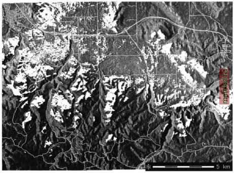 Figure 5.7. Visibility impact analysis of sample windpower plant east of Spearfish (cross northwest on the map, east of Spearfish). The visibility map is overlayed over the elevation model, and it is displayed together with the vector roads map observer location at a given altitude over the ground. The output map cell values represent the vertical angle (in degree) required to see those cells from the observer location. We introduce the usage of this module with an example: Suppose that there is a plan to build a wind power plant east of Spearfish at coordinates 593670E and 4926877N. Concerns about visual and noise impacts may arise for the residents in Spearfish, and our task is to find out where the 50 m high power plant will be visible. For the sake of simplicity, assume that sound propagates similarly to light. To perform this type of analysis, we can use a line of sight method implemented in the module r.los. Note that the module does not include any wind direction algorithm which may be needed to further analyze the noise distribution. We use the elevation model as an input for analysis, specify the coordinates and the height of the power plant. The max parameter is needed to define the maximum visibility distance (here 50 km): r.los ln=elevation.dem out=plant.los coord=593670,4926877\ obs=50 max=50000 d.rast elevation.dem d.rast -o roads d.rast -o plant.los d.barscale -m The results show that the wind power plant is not visible in Spearfish, but widely in the other directions (compare Figure 5.7). Further impact studies would be required in the real world to identify the implications of planning a wind power plant. Potential wind power and other impacts have to be analyzed as well as other issues. Figure 5.8 shows a simplified planning procedure to find a location for a windpower plant. The wind power conditions may be coded in r.mapcalc to derive the final map from a set of input maps. 5.4.6 Landscape structure analysis and modeling Because we could not cover every command and capability useful for processing and analyzing raster data, we would like to encourage you to further explore additional modules, such as r.le commands (Baker and Cai, 1992; 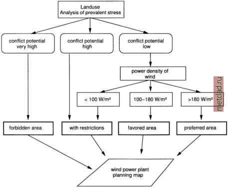 Figure 5.8. Simplified planning procedure to find a location for a windpower plant NOTES 1 Spearfish data set related documents, http: grass.itc.it/data.html Baker, 2001) for quantitative analysis of landscape structure: r.le.patch, r.le.pixel, r.le.setup, r.le.trace; r.topmodel, and r.topidx for hydrologic modeling, or r.ros for wildfire spread simulation. For complete list of modules see the GRASS users manual called by g.manual.
|