
|
|
|
|
Главная --> Промиздат --> Map principle 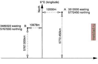 0°N (latitude) - equator East Figure 2.4. Example for the Gauss-Kruger Grid System with two points A and B from the equator, the easting values are measured from the central meridian. To avoid negative values, a false easting of 500,000 m is defined in addition to the third of the longitude of the central meridian. For example the false easting for the 9° E central meridian is 3,500,000 m (9/3 = 3, value composed with 500,000 m to 3,500,000 m). 2.2.3 North American and European Datums In general, a large number of georeferencing datums exists, here we focus on three examples. The North American Datum 1983 (NAD83) is a geodetic reference system which uses as its origin the Earths center of mass, whereas the old North American Datum 1927 (NAD27) had a different origin, making it useful only in North America. GPS receivers which are mostly based on the WGS84 datum (other local datums can be selected in the GPS receivers menu) also use the Earths center of mass as their systems origin. When using maps based on different datums, a datum transformation to a common datum is required. For example, a change from NAD27 to NAD83 system leads to a shift for the entire map. Overlapping maps based on different datums of the same region would not co-register properly without datum transformation. In the continental United States a few common assignments between datums and ellipsoids are in use: NAD27 datum with Clarke 1866 el- NOTES 1 HDF format and tools, http: hdf.ncsa.uiuc.edu 2 PostGIS DBMS, http: postgis.refractions.net 3 National Atlas of the U.S., http: nationalatlas.gov 4 MapQuest, http: www.mapquest.com 5 UMN/MapServer Gallery, http: mapserver.gis.umn.edu 6 ICENS Spatial Information System, http: 196.3.4.220:80 0 0/jdb/icens.sivs?class=gis 7 Grules (GRASS JAVA Server), http: grules.sourceforge.net 8 GeoVRML, http: www.geovrml.org 9 Information about national grid systems: ASPRS: Grids & Datums, http: www.asprs.org/asprs/resources/grids/ European coordinate systems, http: www.mapref.org A comprehensive, general list of projection transformations is available at http: www.remotesensing.org/geotiff/proj list/ 10Unit 013 Coordinate System Overview in the NCGIA Core Curriculum in GIS, http: www.ncgia.ucsb.edu/education/curricula/ giscc/units/u013/u013.html lipsoid, NAD83 datum with GRS80 ellipsoid, and WGS84 datum with WGS84 ellipsoid. It is important to know that the NAD27 and NAD83 datums are 2D horizontal datums used for horizontal coordinates (easting and northing). WGS84 is a 3D datum (x, y and height). Separate vertical datums used with these systems are NGVD29 and NAVD88. GRASS does not handle such separate vertical datums so these transformation needs to be done outside GRASS. Chapter 3 GETTING STARTED WITH GRASS In this chapter we begin working with GRASS. First, we explain GRASS software installation and the structure of its database. Then we use a sample database to perform basic GIS tasks. We also include a number of examples illustrating how to start a GRASS project using different coordinate systems. 3.1. FIRST STEPS GRASS, as a multipurpose GIS, with data organized as raster, vector and site map layers, provides a wide range of tools to support most of the GIS functionality outlined in the previous sections. The overview is given in Table 3.1. Detailed explanation of each module, often with a usage example, is given in the GRASS users manual (see your GRASS installation or Web site1; this manual is based on a publication by the U.S. Army CERL, 1993). While the support for temporal and volume data in GRASS 5.3 is still limited, the GRASS 5.7 that is currently under development, is being designed as full 3D GIS with support for 3D raster, 3D vector and 3D site data (see Blazek et al., 2002; Neteler, 2001a). 3.1.1 Download and install GRASS GRASS software can be downloaded free of charge from the main GRASS Web site: http: grass.itc.it The ITC-irst GRASS site is mirrored in several countries for faster access including the GRASS U.S.A. mirror at http: grass.ibiblio.org.
|