
|
|
|
|
Главная --> Промиздат --> Map principle NOTES 1 GRASS 5.3 users manual, http: grass.itc.it/gdp/online.html 2 FreeGIS Web portal, http: www.freegis.org 3 OpenOSX site, http: openosx.com/products.html 4 Source for Spearfish data set: http: grass.itc.it (section sample data ) 5 Description of Spearfish data set, http: grass.itc.it/gdp/tutorial/spearDB.ps.gz 6 PROJ4 Web site, http: www.remotesensing.org/proj/ 7 National Atlas of the U.S. download area, http: nationalatlas.gov/atlasftp.html 8 GDAL library, http: www.remotesensing.org/gdal/ OGR library, http: www.remotesensing.org/gdal/ogr/ 9 GLCF Maryland LANDSAT data for Spearfish (SD) region, ftp: ftp.glcf.umiacs.umd.edu/glcf/Landsat/WRS2/ p033/r029/ 10 Spearfish LANDSAT-TM7 scene, spatial subset, reprojected to UTM/NAD27: http: mpa.itc.it/grasstutor/, data sets, file p033r029 2 0000712 NAD2 7 small.tar.gz Chapter 4 GRASS DATA MODELS AND DATA EXCHANGE GRASS stores the georeferenced data as raster, vector and site map layers. In this chapter, we explain the basic properties of GRASS data models and their management. The import and export for the various raster, vector and point data formats is presented, including a number of examples. 4.1. RASTER DATA Raster data, stored in GRASS as a matrix of values, represent either a continuous field (surface), an image, or geometric objects (points, lines, areas) corresponding to discrete fields (Figure 4.1). For surfaces, the values in the matrix are assigned to the center points of grid cells. They represent the actual measured or computed values (e.g. elevation, slope, temperature). For non-continuous fields (images, geometric objects), the values are assigned to the entire cell area and represent the category number. 4.1.1 GRASS raster data model A raster map layer is stored in GRASS as a set of files, which include the raster data and their description, organized as follows: generic matrix of values in a compressed format which depends on the raster data type (integer, floating point or 3D grid); map header which contains georeferencing data, resolution, number of rows and columns, range of values and histogram; optional category file which contains text or numeric labels; optional color table; optional timestamp; history file which contains metadata such as the data source or other information provided by the user; reclass table for a map that is a reclassification of another map. All this information is stored in the relevant subdirectories in the LOCA-TION/MAPSET directory. In the following sections, we describe how these components are managed and queried. In GRASS, raster data can be stored as a 2D integer grid, 2D floating point grid (single or double precision), or a 3D floating point grid (single or double precision). The internal GRASS raster data storage format is architecture independent and portable between 32 bit and 64 bit machines. As a result of that a GRASS DATABASE may be accessed in a heterogeneous network file sys- 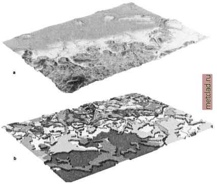 Figure 4.1. Types of raster data: a) continuous field, b) discrete areas
|