
|
|
|
|
Главная --> Промиздат --> Map principle 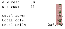 Do you accept this region? (y/n) [y] > у LOCATION <spearfishNAD83> created! Hit RETURN -> If everything is correct, type y and RETURN and you will get back to the startup screen. Type <ESC><ENTER> again and you will get the message that your MAPSET does not exist yet (note that the MAPSET PERMANENT was created automatically): Mapset <<userl>> is not available Mapsets in location <> (+)PERMANENT note: you only have access to mapsets marked with {+) Would you like to create < userl > as a new mapset? (y/n) у Type y and your new LOCATION with your MAPSET are created and GRASS prompt appears. You are now working in GRASS. You can check the definition of your LOCATION by running:  which gives you the projection, coordinate system and units information that you have defined as well as the minimum and maximum coordinates and resolution in the LOCATION coordinate system with the flag -p or in geographic coordinates with the flag -l. Now you can start working on your project, by importing some data as explained in the chapters about raster, vector and site data processing. 3.2.3 State Plane As we have mentioned, the dialog used for the LOCATION definitions will vary depending on the coordinate system. We will illustrate it by the following example, where we use the State Plane Coordinate System. First we need to find out the coordinates of our study region as well as the ellipsoid and datum information (e.g., from the metadata of the file that we plan to import). Then we can start GRASS, provide the name of the new LOCATION, in our example, wake-spm and MAPSET, e.g., userl. Then type <ESC><ENTER> and after going through the previously described steps, you will be prompted for coordinate system. Select D for other and proceed as follows: Please specify the coordinate system for location <spearfishSPF> A X, у В Latitude-Longitude С UTM D Other Projection RETURN to cancel > D [. . .] Please enter a one line description for location <spearfishSPF> > Spearfish State Plane Feet NAD27 Please specify projection name Enter list for the list of available projections Hit RETURN to cancel request > list 11 - Lat/Lon utm - Universe Transverse Mercator stp State Plane aea - Albers Equal Area [...] Based on a list of supported projections, select stp for State Plane and then we continue by providing the rest of the parameters similarly, using list to get the supported options and then selecting the one that applies to our case (we show only the question and answer here, State FIPS code for South Dakota is 46, County FIPS code for Lawrence county is 81): 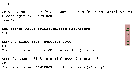 Specify State Plane 1927 or 1983 Enter 27 or 83 Hit RETURN to cancel request >27 Specify the correct units to use: Enter the corresponding number 1. US Survey Foot (Default for State Plane 1927) 2. International Foot 3. Meter >1 After providing the units you will get to the DEFINE THE DEFAULT REGION screen (see our previous example). Now provide the coordinates of the north, south, west and east edge of your project area (in our case N: 271680, S: 195240, W: 977640, E: 1068000) and a suitable resolution (for example 30 m, remember, that you may change it for your work any time using g.region): projection: 2 (State Plane) zone: 0 datum: nad2 7 ellipsoid: a=6378206.4 es=0.006768657997291094 north: 271680 south: 195240 west: 977640 east: 1068000 e-w res: n-s res: 30 30 total rows: total cols: 2548 3012 total cells: 7,674,576 Do you accept this region? (y/n) [y] > у After approving your region parameters and new MAPSET creations (see the previous example) you will get the GRASS prompt and you can start working with your Spearfish data in State Plane coordinate system. 3.2.4 Non-georeferenced xy coordinate system If you need to work with non-georeferenced data or you do not know the parameters of your coordinate system, or your coordinate system is not supported by GRASS, you can define a LOCATION in a general, non-georeferenced coordinate system xy.
|